Rozanna Purcell is shortlisted for Bookstation Lifestyle Book of the Year in the An Post Irish Book Awards. You can vote at irishbookawards.ie. Below is an extract of The Hike Life.
Urris Lakes Loop
Ir. Iorras is an obsolete Irish word for 'peninsula'
What You Need to Know
OSI: 2/3
Distance: 6.5km
Approx. time: 2.5–3 hours
Difficulty: moderate–hard
Route type: looped
Starting point: Urris Lakes Loop, Lenan, Lenankeel, Co. Donegal
Elevation: 380m
Parking: yes, at the Leenakeel Bay Beach, there is a layby for parking, about 10–12 spaces
Fee: no
Dog friendly: no
Recommended mountain leader: Iain Miller; uniqueascent.ie
If you were to ask for my top three hikes from this book, Urris Lakes Loop would be one of them. The Urris Loop Trail is located in the Urris valley on the Inishowen Peninsula, the largest of Donegal’s peninsulas. At its highest point is Malin Head, Ireland’s most northerly place, visible on a clear day from the trail.
Although not an island, the name Inishowen translates as ‘Eoghan’s island’, referring to the fact that most communication and trade with the peninsula used to be by water, across Lough Foyle or Lough Swilly, as opposed to over the rugged Urris Hills. In my opinion, the Inishowen Peninsula doesn’t get enough praise for just how spectacular it is. There is so much to do in this part of Ireland; and so, I have given a pit stop list that covers the whole of Inishowen.
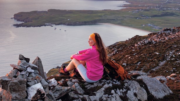
The isolated geography of the Urris valley no doubt played a role in it becoming a thriving centre for illegal Poitín distillation in the 1800s, known as the ‘Poitin Republic of Urris’. This trail offers wonderful views of Lough Swilly, and it was here in November 1798 that Theobald Wolfe Tone, the leader of the 1798 Rebellion, was captured by the Royal Navy.
For a remote hike, the trail is very well-marked, and offers lots of different vistas, from mountainous lake views to coastal cliffs, bays and out to sea. It has it all in terms of scenery!
The parking for this hike is at the nearby beach, so it is best to do this hike at off-peak times when the beach is not busy. Remember to never block local access or gates.

PIT STOPS
Visit
- Wild Ireland, wildlife park
- Wild Alpaca Way
- Oceanwaves Sauna, Culdaff Beach
- The Sea View Sauna, Shrove Beach
- Malin Head and Pracha Viewpoint
- Irish Adventures at Fort Dunree (for kayaking)
- Five Finger Strand Lookout
- Grianán of Aileach
- Doagh Famine Village
- Farren’s Bar, Malin Head (Ireland’s most northerly pub)
Swim
- Leenakeel Bay Beach
- Culdaff Beach
- Big White Bay, Shrove
- Dunree Bay
Eat
- Cúl a’ Tí, Culdaff
- Tank and Skinny’s Seaside, Buncrana
- Ubiquitous
- Corner Deli
- Nancy’s Barn, Ballyliffin
- Market House Café, Clonmany

THE TRAIL
Note: The trail is very well-marked by purple arrows and ‘Urris Lakes Loop’ signs. There are two sections where the markers are far apart, as referenced below. I would recommend using another form of navigation as well as the markers.
From the beachside parking, it’s a short 200m walk to the trailhead.
Pass through the metal farm gate onto the trail, then follow this stony roadway as it quickly rises up; you’ll notice it’s a good pull right from the get-go.
Almost immediately, after 80m, you will come to a junction, from there follow the purple arrows up to the left.
Continue to follow the stony roadway. At approx. 640m, the trail turns right; now follow the purple arrows passing by another metal farm gate.
From here the trail meanders, descending a little.
At approx. 980m keep left, following the purple arrows to pass over a bridge and then immediately turn left, following the purple arrows up a stony roadway.
Note: While this section is all marked, pay attention at the junctions.
From here the trail ascends. As it gradually rises, the stony terrain turns rockier, with sections of grass the higher up you hike.
At approx. 2km, the purple arrow leads you left onto a very narrow and boggy trail; there are some planks and steps cut into the mountainside along this section. The trail here is very distinct and clearly marked.
At approx. 2.3km, the trail turns grassy and boggy. Along this section it is important to look out for the markers, as the trail becomes less distinct.
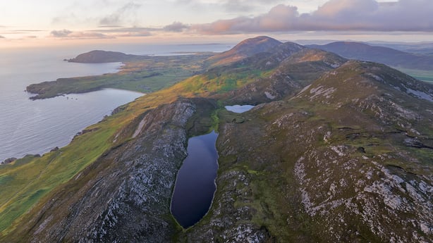
At approx. 2.5km, you will reach the first lake, Crunlough; it will be to your left-hand side.
Note: There are fantastic echoes here!

Note: The Urris Lakes Loop does not go around either of the lakes on this hike, as the trail name might suggest. There are lots of sheep tracks leading around the lake which might confuse you.
Continue past the first lake, which is on your left-hand side. This section of trail is boggy and runs through long grass. Keep an eye out for the marker pole ahead, as it can be tricky to see at this section.
At approx. 2.8km, you will see the second lake, Lough Fad, then just before you get to the lake, the trail turns right and becomes a narrow and rocky trail.
The trail rises up, veering left to run along the north-west side of Urris Hill; be sure to look out for the sea views on your right-hand side. This section of trail is my favourite and a great spot to take a break and admire the views.
Note: This section of trail has many steep drops so look out for these.
At approx. 3.4km, the trail veers right and begins to loop back down and runs along a lower trail on the side of the hill. This section of trail is narrow and boggy, with a few very steep sections to descend.
At approx. 4.5km, you rejoin your original trail back down, returning via the stony roadway.
At approx. 5.7km, on your return to the junction, instead of going right (the way you came), you can go left returning via the lower roadway back to the trailhead start point and passing back through the metal farm gate onto the road and back down to the beach.


